 |
| Stage III Signs Along FM 1626 |
The fall provided little relief and on October 20, 2022, Critical Drought (Stage III) was declared as the Lovelady Monitor Well passed below its Stage III threshold on October 17, 2022.
A combined 8.2 inches of rain fell from January to April (0.8 inches below historical average), which provided enough recharge to keep spring flow and water levels hovering just above the Stage II Alarm Drought thresholds. The Climate Prediction Center (CPC) announced that La Niña conditions built up strength in February and were favored to continue into the summer. The impact of drier-than-usual conditions early in the year were seen in regional aquifers when Barton Springs flow began to decline in early February and Lovelady water level followed in early March.
A combined 6.7 inches of spring rain fell from March through June, almost 7 inches below historical average. May and June, which are historically the wettest months of the year in Central Texas, were both well below their historical monthly averages (-2.8 & -2.7 respectively). In fact, both May and June 2022 were documented as the warmest on record in Austin, which perpetuated the downward spring flow and water level trends. With Barton Springs and Lovelady water levels falling below their respective Stage II Alarm thresholds in early June, the Board declared Stage II Alarm Drought conditions on June 9, 2022.
In July 2022, the CPC predicted a high probability for La Niña to persist into fall and early winter. This indicated that aquifer conditions were likely destined for intensifying drought. A combined 5.6 inches of rain from July to October (5.5 inches below historical monthly average) and a 38-day dry stretch from early September to mid-October provided little-to-no recharge. Aquifer levels and spring flow continued to decline and on October 17th the Lovelady Monitor Well crossed under its Stage III threshold triggering the Board to declare Stage III Critical Drought on October 20, 2022.
 |
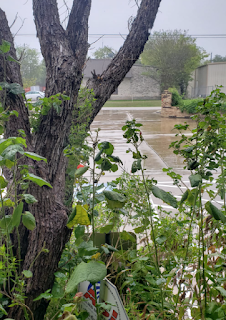
| Rain in November 2022 |
To summarize, the Austin/Hill Country ended 2022 as the region’s driest year since the drought-plagued and heat-record setting year of 2011, with an average 21 inches of rainfall in 2022. This was 13 inches below the annual average and just over half as much as the 36 inches in 2021. Forecasted below-average rainfall with persistent La Niña conditions indicate we could be in for a dry spring 2023. However, things could change for the better after the Spring.
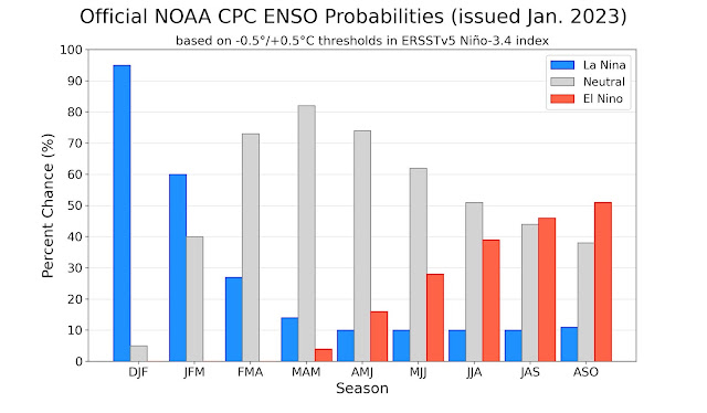
The National Weather Service provided the latest ENSO (El Niño/Southern Oscillation) outlook. Although La Niña conditions remain in place, a return to ENSO-neutral conditions is imminent. Later in 2023, odds favor El Niño development. This would bring wetter, cooler than normal weather for South Central Texas by late fall or winter, if El Niño does develop. It should be noted that many of our historical floods have happened during El Niño.
 |
| Official NOAA CPC ENSO Probabilities (issued Jan. 2023) |
Conservation continues to be the best practice for all of Central Texas as we anticipate dry conditions to come. We are off to a slow start when it comes to precipitation. Check out the rain hydrograph below.
The District recommends that both exempt and permitted well owners follow these conservation tips. For additional information on groundwater wells, please take a look at the District's Well Owner Guide. If you have questions about your well, please contact us at 512-282-8441. We encourage you to call or visit our office (1124 Regal Row, Austin, TX) during office hours (8 a.m. to 5 p.m.) to review our groundwater management process, receive information about the drought, or if you need assistance with other groundwater related matters.
Useful links:
Drought Information
Frequently Asked Questions
Drought Media Tool Kit
Drought Status Page
Drought Management Page
.jpg)


